The exact page text, read by your browser's voice.
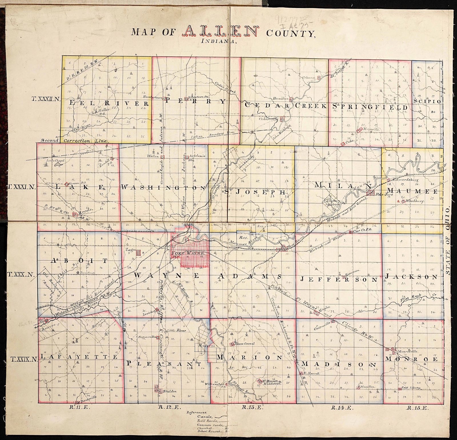

Before it was a townsite it was a transaction waiting to happen, and this section is the paper trail of the ground itself. The land at the meeting of the St. Joseph and St. Marys, the head of the Maumee above the portage to the Wabash, was Miami country, held by occupation, council, burial and trade, with Kekionga's council house the seat of a nation's government. The cessions came by treaty, each one an article in this section: Greenville in 1795, whose line left Fort Wayne's ground on the Miami side; the treaty signed at the fort in 1803, about land elsewhere; Harrison's 1809 treaty, three million acres down the Wabash; and St. Mary's in 1818, the cession that made the townsite saleable and opened the New Purchase on which Indianapolis would be platted. The section reads the treaties as the land's title history, because that is what they were.
The starting title: Miami country under other men's paper
Before 1795 — possession on the ground, claims on paper elsewhere
The ground: The land at the meeting of the St. Joseph and St. Marys rivers — the head of the Maumee, above the short portage to the Little River and the Wabash — was Miami country, and its capital town was Kekionga. The Miami…
Greenville, 1795: the six miles square at the confluence
3 August 1795 — Treaty of Greenville, 7 Stat. 49
The transaction: The Treaty of Greenville ended the Northwest Indian War on General Anthony Wayne's terms. Its third article drew the general boundary — from the Cuyahoga portage west to Fort Recovery, then southwest to the Ohio…
Fort Wayne, 1803: a treaty signed here, about land elsewhere
7 June 1803 — Treaty of Fort Wayne, 7 Stat. 74
The transaction: The first treaty that bears this place's name was concluded at the fort on 7 June 1803, between Governor William Henry Harrison and the Delaware, Shawnee, Potawatomi, Eel River, Wea, Kickapoo, Piankashaw and…
Fort Wayne, 1809: three million acres down the Wabash
30 September 1809 — Treaty of Fort Wayne, 7 Stat. 113
The transaction: Harrison came back to Fort Wayne in September 1809 and took the largest cession yet from the Miami, Eel River, Delaware and Potawatomi. The first article ceded two tracts: a strip thirty miles wide at its…
St. Mary's, 1818: the cession that made the townsite saleable
6 October 1818 — Treaty with the Miami at St. Mary's, Ohio, 7 Stat. 189
The transaction: At St. Mary's, Ohio, commissioners Jonathan Jennings, Lewis Cass and Benjamin Parke took from the Miami the cession that opened central Indiana — the "New Purchase" on which Indianapolis would be platted three…
The Richardville grants: 28,320 acres, treaty by treaty
1818–1840 — the largest private holding ever laid on this ground
The 1818 grants: Article 3 of St. Mary's granted Jean Baptiste Richardville, by patent in fee simple, a schedule of tracts that the Park Service's nomination totals at eleven sections — 7,040 acres. Five of the sections lay on…
The other reserves on and around this ground
1818–1850 — Godfroy, Charley, the Ten Mile Reserve, and the Longlois
Godfroy: Francis Godfroy, war chief and the Richardvilles' great rival in the trade, took his grants where his trading houses stood, down the Wabash. The 1834 treaty, commuting older grants, recites four sections on the Salamonie…
Paradise Springs, 1826: the claim north of the rivers ends
23 October 1826 — Treaty with the Miami, near the mouth of the Mississinewa, 7 Stat. 300
The transaction: Commissioners Lewis Cass, James B. Ray and John Tipton — the Fort Wayne Indian agent, negotiating the cession of the country around his own agency — took from the Miami, at Paradise Springs near the mouth of the…
The canal grant, 1827: the state becomes a landowner
2 March 1827 — Act of Congress, 4 Stat. 236
The transaction: The United States had already, by the act of 26 May 1824, authorized Indiana to survey a canal through the public lands between the Wabash and the Maumee and reserved ninety feet of land on each side of the line…
The Forks of the Wabash, 1834 and 1838: the reserves are bought back
23 October 1834 and 6 November 1838 — 7 Stat. 458; 7 Stat. 569
1834: At the Forks of the Wabash — Richardville's own seat, at present Huntington — Commissioner William Marshall bought back the tribal reserves the 1826 treaty had created eight years before: thirty-six sections at Flat Belly's…
The Forks of the Wabash, 1840: the remainder of the Big Reserve
28 November 1840 — Treaty with the Miamies, 7 Stat. 582
The transaction: The last cession was negotiated at the Forks of the Wabash by Samuel Milroy and — the record's own irony — Allen Hamilton, Fort Wayne's banker, acting unofficially as commissioners for the United States. The…
The treaties that did not touch this ground
1821–1828 — Chicago, St. Joseph, and the Michigan Road, answered plainly
Chicago, 29 August 1821: The Treaty of Chicago took from the Ottawa, Chippewa and Potawatomi a great tract in present Michigan, its southern line running to the Indiana boundary country west of this county. It ceded no Allen…
The survey: the rectangular grid laid over the cessions
1822–1824 — the Second Principal Meridian townships
The system: Ceded land could not be sold until it was surveyed, and the survey that reached Fort Wayne was the federal rectangular survey: townships six miles square, divided into thirty-six sections of 640 acres, numbered off…
The land office and the first sales
22 October 1823 — the Fort Wayne Land District opens
The district: By act of Congress approved 8 May 1822, the lands ceded at St. Mary's were laid out as a federal land district with its office at Fort Wayne. Because the district was not yet surveyed, the offices stood vacant until…
Who bought the townsite: Barr and McCorkle
1823–1824 — the original plat, 118 lots over 109 acres
The buyers: The ground the town stands on was bought from the United States by John T. Barr of Baltimore and John McCorkle of Piqua, Ohio. The county histories name them, in John W. Dawson's phrase, the "original purchasers," and…
The forty acres: county purchase and canal land inside the plat
1820s–1830 — the military reservation divided
The tract: Beside the proprietors' plat lay forty acres of military reservation, ground the Army had held with the fort. When the garrison era ended, Congress disposed of that forty in two halves, and Dawson's account of the…
The speculation era: the first buyers and the bust
1823–1841 — Ewington, Hanna's additions, and the panic
The first buyers: The men who bought at the first sales were, in the main, the men of the preceding entries wearing their other hats. Alexander Ewing, the Irish immigrant who had first seen Fort Wayne in the column that broke the…
The reserved sections: school lands and swamp lands
1785–1850 — the sections the sales skipped
Section 16: Under the federal land ordinance system Indiana inherited, the sixteenth section of every township was reserved from ordinary sale for the support of public schools — one square mile in every thirty-six, held by the…
By 1850 the map is private
1850–1876 — closing frame
The completed transfer: Read the record in sequence and the transfer takes fifty-five years and nine instruments: Greenville's six miles square in 1795; the venue treaties of 1803 and 1809 moving the boundaries; St. Mary's in…